| | | MAP SYMBOLS |  | Town |  | Town with accommodation |
|
| | |
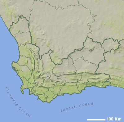
| | | MOST POPULAR DESTINATIONS | |
|
| |
| | SMALLER SCALE MAP (ZOOM OUT) | |
| MORE MAPS RELATED TO WESTERN CAPE | | Free map of Stellenbosch CBD
Size: 300 x 210 mm
Price: |
| Free map of the Stellenbosch and Franschhoek region
Size: 282 x 197 mm
Price: |
| Example of Game Farm Map
Size: 1040 x 520 mm
Price: |
| South-West Coast Perspective Map
Size: 940 x 720 mm
Price: |
| Cape Town and Overberg Perspective Map
Size: 940 x 600 mm
Price: |
| Kogelberg Perspective Map
Size: 940 x 670 mm
Price: |
| Boland Perspective Map
Size: 900 x 940 mm
Price: |
| Garden Route Map (western direction)
Size: 470 x 734 mm
Price: |
| South Western Cape
Size: 1000 x 770 mm
Price: |
| Garden Route and Karoo
Size: 1000 x 700 mm
Price: |
| Cape Town Travel Map
Size: 528 x 412 mm
Price: |
| Free Table Mountain Map
Size: 2723 x 2630 mm
Price: |
| Free Cape Town City Centre Map
Size: 1911 x 2630 mm
Price: |
| Free Camps Bay Map
Size: 1 x 0 mm
Price: |
| Free Plettenberg Bay Map
Size: 1304 x 3428 mm
Price: |
| Free Knysna Map
Size: 1304 x 3428 mm
Price: |
| Free Mossel Bay Map
Size: 1304 x 3428 mm
Price: |
| Free George Map
Size: 2361 x 1181 mm
Price: |
| Free Oudtshoorn Map
Size: 2361 x 1181 mm
Price: |
| Garden Route & Klein Karoo
Size: 562 x 624 mm
Price: |
|
| |