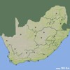
Map of Free State
Free State
maps
>
South Africa
>
Free State
sa
explorer
|
Information
by Location
HOME
|
SERVICES
|
MAPS
PLACES
ACCOMMODATION
DISTANCES
CAR
RENTAL
Search:
GO!
MAP SYMBOLS
Town
Town with accommodation
MOST POPULAR TOOLS
Travel Distance Calculator
Accommodation Finder
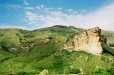
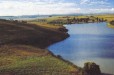
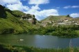
SELECTED IMAGES
MOST POPULAR DESTINATIONS
Bloemfontein
Clarens
Welkom
Gariep Dam
Ficksburg
Smithfield
Fouriesburg
Ladybrand
Bethlehem
Van Reenen
Parys
Deneysville
Kroonstad
Harrismith
Luckhoff
Steynsrus
Lindley
Odendaalsrus
Warden
Hennenman
Arlington
Ventersburg
Hertzogville
LINKS
SMALLER SCALE MAP (ZOOM OUT)
South Africa Map
Provinces:
Eastern Cape
,
Free State
,
Gauteng
,
Kwa-zulu Natal
,
Limpopo
,
Mpumalanga
,
Northern Cape
,
North West
and
Western Cape
.
MORE MAPS RELATED TO FREE STATE
2023 � SA Explorer