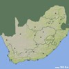
Map of Northern Cape
Northern Cape
maps
>
South Africa
>
Northern Cape
sa
explorer
|
Information
by Location
HOME
|
SERVICES
|
MAPS
PLACES
ACCOMMODATION
DISTANCES
CAR
RENTAL
Search:
GO!
MAP SYMBOLS
Town
Town with accommodation
MOST POPULAR TOOLS
Travel Distance Calculator
Accommodation Finder
SELECTED IMAGES
MOST POPULAR DESTINATIONS
Upington
Colesberg
Kuruman
De Aar
Kimberley
Mccarthys Rest
Barkly West
Port Nolloth
Groblershoop
Griekwastad
Kakamas
Keimoes
Britstown
Postmasburg
Hanover
Richmond (nc)
Loxton
Kathu
Pella
Deben
Onseepkans
Hotazel
Black Rock
LINKS
SMALLER SCALE MAP (ZOOM OUT)
South Africa Map
Provinces:
Eastern Cape
,
Free State
,
Gauteng
,
Kwa-zulu Natal
,
Limpopo
,
Mpumalanga
,
Northern Cape
,
North West
and
Western Cape
.
MORE MAPS RELATED TO NORTHERN CAPE
2023 � SA Explorer