Knysna maps
> South Africa > Western Cape > Knysna
saexplorer|Information
by  Location
HOME | SERVICES | 
    

  MAPS  

  PLACES  

  ACCOMMODATION  

  DISTANCES  

  CAR RENTAL  

  CLIMATE  

Search: GO! 
 
SYMBOLS USED ON THE INTERACTIVE MAP ABOVE
Location highlighter
Zoom in to detail map
TownWilderness area
Town with accommodationNational Park / Reserve
AdventureMountain bike route
Major route4x4 Trail
Minor routeHiking
AccommodationWine tasting
AttractionPhoto (north orientated)
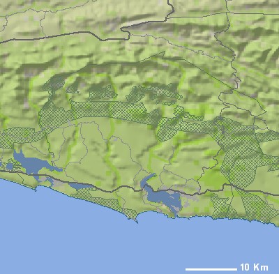
IMAGES IN OR NEAR KNYSNA
Buffelsbaai
SPONSORS
 
OTHER INTERACTIVE MAPS RELATED TO KNYSNA
South Africa Map
Places of interest: Cape Town, Knysna, Johannesburg, Durban, Stellenbosch, Hout Bay, Plettenberg Bay, Pretoria, Hermanus and Oudtshoorn.
Eastern Cape Map
Places of interest: Knysna, Durban, Plettenberg Bay, Port Elizabeth, East London, Bloemfontein, Umhlanga, Wilderness, Addo and Jeffreys Bay.
Western Cape Map
Places of interest: Cape Town, Knysna, Stellenbosch, Hout Bay, Plettenberg Bay, Oudtshoorn, Hermanus, Franschhoek, Montagu and Camps Bay.
Western Eastern Cape Map
Places of interest: Knysna, Plettenberg Bay, Port Elizabeth, Wilderness, Addo, Jeffreys Bay, George, Graaff-Reinet, Port Alfred and Grahamstown.
Greater Uniondale Map
Places of interest: Knysna, Plettenberg Bay, Oudtshoorn, Wilderness, George, Sedgefield, Herolds Bay, De Rust, Belvidere Estate and Uniondale.
MORE MAPS RELATED TO KNYSNA
Garden Route Map (western direction)
Size: 470 x 734 mm
Price:
Garden Route and Karoo
Size: 1000 x 700 mm
Price:
Free Knysna Map
Size: 1304 x 3428 mm
Price:
Garden Route & Klein Karoo
Size: 562 x 624 mm
Price:
 
 
2022 © SA Explorer